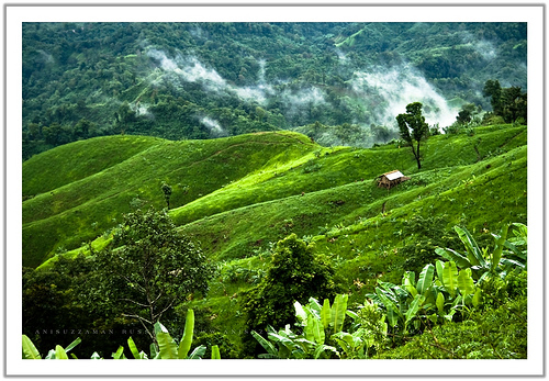
Bandarban is a extreme natural beauty of Bangladesh.
 Bandarban (Bengali: বান্দরবান) is a district in South-Eastern Bangladesh, and a part of the Chittagong Division and Chittagong Hill Tracts. Bandarban is regarded as one of the most attractive travel places in Bangladesh. Bandarban (meaning the dam of monkeys), It also is the administrative headquarter of Bandarban district, which has turned into one of the most exotic tourist attractions in Bangladesh since the insurgency in Chittagong Hill Tracts has ceased more than a decade back.
Geography
One of the three hill districts of Bangladesh and a part of the Chittagong Hill Tracts, Bandarban (4,479 km²) is not only the remotest district of the country, but also is the least populated (population 292,900). The three highest peak of Bangladesh - Tahjindong (1280 meters, also known as bijoy)[* The height of Tahjindong is 829.66m +/-3m as per a recent measurement with Garmin GPSMAP60CSX GPS], Mowdok Mual (1052 m), and Keokradong (1230 m) [* The height of Keokradong is 986m +/-3m as per a recent measurement with Garmin GPSMAP60CX GPS], - are located in Bandarban district, as well as Raikhiang Lake, the highest lake in Bangladesh. Chimbuk peak and Boga Lake are two more highly noted features of the district. The newly reported highest peak of Bangladesh - Saka Haphong (3488 ft) is also here in Thanchi upazila.The Nafa-khum falls
 Tourism

welcome guets, but don't want Bandarban to become croweded or polluted like rangamati, We don't want to lose our culture nor see it consigned to a museum
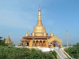
Balaghata Buddhist Temple
Bandarban lies, by bus, eight hours away from Dhaka, two hours from Chittagong and three hours from Cox's Bazaar. It is also possible to get there by a six hour bus ride from Rangamati.Balaghata Buddhist Temple
The Buddha Dhatu Jadi, the largest Buddhist temple in Bangladesh, located in Balaghata, 4 km from the town.This place attracts many tourists every year. This Theravada Buddhist temple is made completely in the style of South-East Asia and houses the second largest statue of Buddha in Bangladesh. The waterfall named Shoilo Propat at Milanchari is another place tourists like to visit.
The hanging bridge at Meghla.
The numerous Buddhist temples, known as kyang in local tongue, and bhihars in the town include the highly notable the Rajvihar (royal vihar) at Jadipara and the Ujanipara Bhihar. Bawm villages around Chimbuk, and Mru villages a little further off, are also lie within a day's journey from the town. Prantik Lake, Jibannagar and Kyachlong Lake are some more places of interest. Boat ride on the river Sangu is one of the main attraction here for tourists.History
In the early days of 15th century, Arakanese kingdom, where Mrauk U was the capital, expended its territories to the Chittagong area of Bengal. After the victory of Arakan on Burma's Pegu kingdom in 1599 AD, the Arakanese king Mong Raja Gree appointed a Prince of Pegu as the governor of newly established Bohmong Htaung (Circle) by giving the title of "Bohmong" Raja. That area was mostly populated by the Arakanese descendants and ruled by the Burmese (Myanmar) noble descendants who started to call themselves in Arakanese language as Marma. Marma is an archaic Arakanese pronunciation for Myanmar. As the population of the Bohmong Htaung were of Arakanese descandants, these Myanmar-descendants Bohmong chiefs (Rajas) of the ruling class took the titles in Arakanese and speak a dialect of the Arakanese language.Bandarban Hill District was once called Bohmong Htaung since the Arakanese rule. Once Bohmong Htaung was ruled by Bohmong Rajas who were the subordinates to the Arakanese kings. Ancestors of the present Bohmong dynasty were the successor of the Pegu King of Burma under the Arakan's rule in Chittagong. In 1614, King Mong Kha Maung, the king of Arakan appointed Maung Saw Pru as Governor of Chittagong who in 1620 repulsed the Portuguese invasion with great valour. As a consequence, Arakanese king, Mong Kha Maung adorned Maung Saw Pru with a title of Bohmong meaning Great General. After the death of Maung Saw Pru two successors retained Bohmong title. During the time of Bohmong Hari Gneo in 1710, Arakanese King Canda Wizaya recaptured Chittagong from the Mughals. Bohmong Hari Gneo helped King Canda Wizaya in recapturing Chittagong and as a mark of gratitude the later conferred on Bohmong Hari Gneo the grand title of Bohmong Gree which means great Commander in Chief.
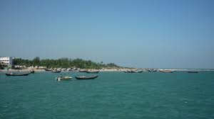
Sangu river plays an important role in the economy of Bandarban.
Tribal People at work
Heavily dependent on Jumm farming, which is a slash and burn agricultural technique, Bandarban produces little that is of economic value outside self consumption of the hill people, also known as Jumia. Fruits (banana, pineapple, jackfruit, papaya), masala (ginger, turmeric) and tribal textile are the major exports of the district, with tourism growing fast as a source of revenue.Much of the trade in fruit, like most other commerce in the district, has been taken over by Bengali settlers.Clothes are mostly made of cotton, wool imported from Myanmar and silk cotton which is a rarity in most of Bangladesh. All cotton is spun and woven by hand. To promote local textile there now is a Bangladesh Small and Cottage Industry Corporation (BSCIC) center in Bandarban together with a wonderful sales centre. BSCIC has also introduced mechanical spinning and weaving here.
Bamboo and tobacco grows in significant quantity, but largely is not considered as economically profitable products. Bamboo is used, along with canes, not just to make the traditional stilt houses, but is the material for most tribal craft, including the bamboo smoking pipe, a major health hazard. Some bamboo-craft and local-made cigarillos are now exported out of the district.
Two church-based development organization - Christian Commission for Development in Bangladesh (CCDB) and Caritas are the major forces of development in the district. UNICEF is driving the education effort, which is mostly directed at younger children.
Ethnographics
The Mru, also known as Murong, who are famous for their music and dance. The Mru in major numbers have converted to the youngest religion in Bangladesh – Khrama(or Crama) – a religion that prohibits much of their old ways. They are proposed as the original inhabitants of Bandarban.
The Bawm are another major tribe here. Now converted almost totally to Christianity they have taken full advantage of the church to become the most educated people in the district.
The Marma, also known as Magh, are of Arakanese descendants and Buddhists by religion, and are the second largest ethnic group in the hill districts of Bangladesh.
The Chakma and the Tanchangya are also closely related. The Khumi live in the remotest parts of the district, and the group is thought to include yet unexplored/ unclassified tribes.
Hilly highway to Bandarban main town.
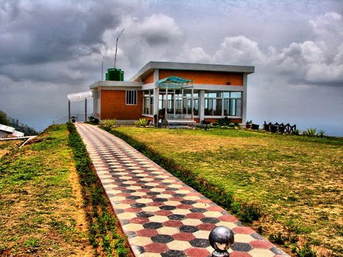
MeghDut cottage at Nilgiri
These ethnic groups are again divided in hundreds of clans and sects, principally dominated by four religious threads - Buddhism, Christianity, Hinduism and Animism. All these clans and groups are clustered into two major ethnic families - the hill people and the valley people - though since the Kaptai dam flooded the valley to give birth to Kaptai lake, the valley people have started to live on hill tops along the hill people.Geography
The three highest peak of Bangladesh - Tahjindong (1280 meters, also known as bijoy), Mowdok Mual (1052 meters), and Keokradong (883 metres) - are located in Bandarban district, as well as Raikhiang Lake, the highest lake in Bangladesh. Chimbuk peak and Boga Lake are two more highly noted features of the district. Though most Bangladesh sources cite Keokradong as the highest peak in the country, but Tazing Dong (sometimes spelled as Tahjingdong, and also known as Bijoy) lying further east is recognized both by government and expert sources as a taller peak. Measurements taken by English adventurer Ginge Fullen shows that an officially unnamed peak near the Myanmar border (locally known as Mowdok Mual) is the highest point in Bangladesh.Recently a team from Nature Adventure Club took part in an expedition in the mowdok range and agreed with the ginge fullens statement. They got the hight of this peak as 3488 feet with gps accuracy of 3 meter. The unnamed summit is known as 'Saka Haphong' to the local Tripura tribes.The Sangu River
The River Sangu (also known as Sangpo or Shankha), the only river born inside Bangladesh territory, runs through Bandarban. The other rivers in the district are Matamuhuri and Bakkhali. Parts of Kaptai Lake, the biggest lake in, Bangladesh fall under the are:There are more than fifteen ethnic minorities living in the district besides the Bengalis, including: the Marma, the Arakanese descendants and Arakanese (Rakhine), who are also known as Magh, Mru (also known as Mro or Murong), Bawm, Khyang, Tripuri (also known as Tipra or Tipperah), Mizo (also known as Lushei), Khumi, Chak, Kuki, Chakma and Tenchungya, who are closely related, Reang (also known as Riyang), Uchoi (also known as Usui) and Pankho.
The Mru, also known as Murong, who are famous for their music and dance. The Mru in major numbers have converted to Khrama (or Crama), the youngest religion in Bangladesh that prohibits much of their old ways. They are assumed to be the original inhabitants of Bandarban. The Bawm are another major tribe here. Now converted almost totally to Christianity they have taken full advantage of the church to become the most educated people in the district. The Marma are Arakanese descendants of Myanmar by origin and Buddhists by religion, and are the second largest tribe in the hill districts of Bangladesh. The Khumi live in the remotest parts of the district, and the group is thought to include yet unexplored/ unclassified tribes.
These ethnic groups are again divided in hundreds of clans and sects, principally dominated by four religious threads - Buddhism, Christianity, Hinduism and a number of pagan faiths. All these clans and groups are clustered into two major ethnic families, namely the hill people and the valley people. Since the Kaptai dam flooded the valley creating to Kaptai lake, the valley people have started to live on hill tops along the hill people.


.png)


